



Lake Malawi is one of Africa’s most remarkable natural landmarks, known for its clear waters, beautiful beaches, diverse fish species, and scenic landscapes. If you are exploring a map Lake Malawi guide, understanding its location, surrounding countries, major settlements, and geographical features will help you appreciate the lake’s importance. Often called the Lake of Stars, this vast freshwater body attracts tourists, researchers, nature lovers, and people interested in African geography.
Located in southeastern Africa, Lake Malawi forms an important geographical feature along the Great Rift Valley. It stretches between Malawi, Mozambique, and Tanzania, providing food, employment, transportation, and tourism opportunities for millions of people. A detailed map Lake Malawi view also reveals the lake’s long, narrow shape and its position among the mountains, plateaus, and communities of the region.
Where Is Lake Malawi Located?
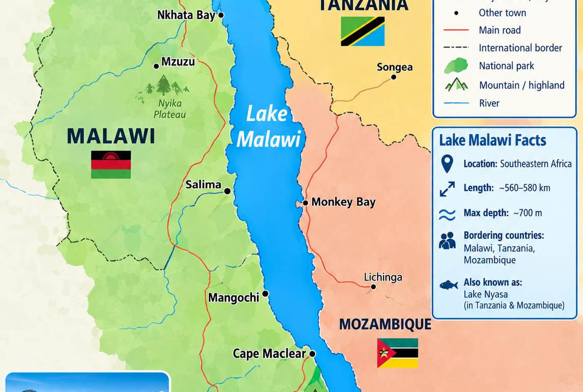
Lake Malawi lies in southeastern Africa, primarily along the eastern side of Malawi. Its northern shores approach Tanzania, while its southern and southeastern waters extend toward Mozambique. The lake occupies part of the East African Rift System, a geological region shaped by the gradual movement of tectonic plates.
When studying a map Lake Malawi, you can identify the lake as a long body of water running approximately from north to south. Its position makes it a major geographical landmark in the region, connecting communities across international borders and supporting ecosystems that depend on freshwater habitats.
The lake is also known as Lake Nyasa in Tanzania and Mozambique. These different names refer to the same body of water, although naming preferences can reflect national and historical perspectives. Recognizing these alternative names can make maps, travel guides, and geographical resources easier to understand.
Understanding the Geography of Lake Malawi
Lake Malawi is among Africa’s largest lakes and ranks among the deepest freshwater lakes in the world. It is approximately 560 to 580 kilometres long, depending on the measurement used, and reaches depths of around 700 metres. Its considerable size makes it a defining feature of southeastern African geography.
A map Lake Malawi reference helps explain how the lake extends through a landscape of highlands, steep slopes, sandy beaches, and populated shorelines. The surrounding terrain changes considerably from one section to another, creating different habitats and travel experiences.
Northern, Central, and Southern Sections
The northern section features deep waters and mountainous scenery. Parts of the shoreline are relatively remote, making this area attractive to visitors seeking quieter natural environments. The northern end also approaches Tanzania, giving the lake international geographical importance.
The central section includes numerous lakeside communities and settlements. Fishing, farming, and local trade contribute to daily life throughout this region. Looking at a map Lake Malawi image can help travellers understand the distance between these communities and the different routes connecting them.
The southern section contains several well-known tourist destinations and accessible beaches. Cape Maclear and areas around Mangochi are popular with visitors interested in swimming, boating, snorkelling, and relaxing beside the water.
Countries Surrounding Lake Malawi
Three countries share the wider Lake Malawi region: Malawi, Tanzania, and Mozambique. Their relationship with the lake influences local economies, environmental management, and regional cooperation.
Malawi
Malawi takes its name from the lake’s neighbouring country and contains most of the lake’s western shoreline. The lake is central to the country’s identity, tourism industry, fishing economy, and transport network. Major lakeside destinations include Nkhata Bay, Salima, Mangochi, and Cape Maclear.
On a map Lake Malawi, the western shore is particularly important because many communities and tourism facilities are situated along this side. Roads connect lakeside settlements with inland towns, allowing visitors to combine lake excursions with other parts of Malawi.
Tanzania
Tanzania borders the northern portion of the lake. The region around its northern shore includes mountainous scenery, rural communities, and access to the wider East African landscape.
When reading a map Lake Malawi illustration, the northern international boundary can help explain why the lake matters to more than one country. Its waters, fish populations, and surrounding habitats create shared environmental interests.
Mozambique
Mozambique borders the eastern and southeastern parts of the lake. Nearby communities depend on fishing and other lake-related activities, while the wider region connects with Mozambique’s inland transport and settlement networks.
A reliable map Lake Malawi resource should clearly identify Mozambique on the eastern side of the lake and show the surrounding international boundaries where available. However, detailed border arrangements and territorial interpretations should be checked against authoritative geographical or government sources.
Major Towns and Destinations Around the Lake
Lake Malawi offers a variety of destinations, from lively fishing towns to peaceful beaches and protected natural areas. Their locations become easier to understand when you compare a geographical map with a road map.
Nkhata Bay
Nkhata Bay is a well-known lakeside town in northern map lake malawi. It attracts travellers with its green hills, waterfront accommodation, local markets, and opportunities to explore the lake. Visitors often use it as a base for boat trips and other water activities.
Salima and Senga Bay
Salima lies inland from parts of the western lakeshore, while Senga Bay is a popular destination near the lake. The area offers beaches, accommodation, and access to recreational activities. Its relative accessibility makes it suitable for travellers planning shorter visits.
Cape Maclear
Cape Maclear is situated on the southern part of map lake malawi and is known for its beaches, clear water, and water-based activities. It is also associated with Lake Malawi National Park, an important protected area recognised for its freshwater biodiversity.
Mangochi
Mangochi is a major town in southern Malawi and provides access to several lakeside destinations. Visitors can use the town as a starting point for exploring nearby beaches, accommodation areas, and cultural attractions.
A map Lake Malawi travel plan that includes these destinations can help visitors compare distances and select a practical route. Travellers should check current road conditions, transport availability, and seasonal access before beginning a journey.
Why Lake Malawi Is Geographically Important
Lake Malawi has significant environmental, economic, and scientific value. Its freshwater supports communities and wildlife while contributing to the wider ecology of southeastern Africa.
Freshwater Biodiversity
The lake is famous for its extraordinary variety of cichlid fish. Many species have evolved within the lake, making it an important natural laboratory for studying evolution, adaptation, and aquatic ecosystems. Scientists examine these fish to understand how species diversify and occupy different ecological niches.
A map Lake Malawi view also helps researchers connect habitats with the lake’s physical features, including depth, shoreline shape, and the distribution of protected areas.
Fishing and Local Livelihoods
Fishing provides food, income, and employment for many lakeside households. Small-scale fishing communities contribute to local markets and regional food supplies. Other residents earn income through boat transport, hospitality, retail, and tourism services.
Because so many livelihoods depend on the lake, sustainable fishing practices and responsible resource management remain essential.
Tourism and Conservation
Tourism brings visitors to the lake for swimming, snorkelling, kayaking, sailing, and wildlife observation. Protected areas help conserve habitats and support environmental education.
Lake Malawi National Park, located in the southern part of the lake, map lake malawi is recognised as a UNESCO World Heritage Site because of its exceptional freshwater biodiversity. Visitors should follow local conservation rules, avoid disturbing wildlife, and dispose of waste responsibly.
How to Read a Map of Lake Malawi
Using a map effectively requires more than identifying the lake’s outline. The type of map you choose should match your purpose.
A physical map displays terrain, elevation, mountains, and water bodies. It is useful for understanding the lake’s relationship with the surrounding landscape. A political map highlights countries, boundaries, and settlements, making it suitable for studying the region’s international geography.
A road map focuses on transport routes, towns, and connections between destinations. Travellers can use it to plan journeys between lakeside communities. Satellite maps provide a more detailed view of beaches, islands, roads, vegetation, and built-up areas.
For the clearest map Lake Malawi experience, compare a general geographical map with a detailed road or satellite map. Check the map’s scale, labels, orientation, and publication date. Digital maps may include updated roads and businesses, but remote areas can have incomplete information or limited mobile coverage.
Best Time to Visit Lake Malawi
The best time to visit depends on the activities you prefer. The dry season, generally from May to October, often provides comfortable conditions for sightseeing and outdoor exploration. June through August can be particularly pleasant for many visitors, although temperatures and conditions vary by location.
The warmer period from November to April brings greater chances of rainfall in many parts of the region. Rain can make some roads more difficult to navigate, but the surrounding landscape may appear greener and more vibrant.
Before travelling, use a map Lake Malawi route planner alongside a local weather forecast. Check accommodation availability, boat schedules, road access, and any local safety guidance. Conditions on the water can change, so follow advice from experienced operators and wear appropriate flotation equipment when required.
Conclusion
Lake Malawi is much more than a large freshwater lake. It is a defining geographical feature of southeastern Africa, a habitat for remarkable aquatic life, a source of food and employment, and a destination for travellers seeking natural beauty. Studying a map Lake Malawi guide makes it easier to understand the lake’s position between Malawi, Tanzania, and Mozambique, as well as the locations of important towns, beaches, and protected areas.
Whether you are researching African geography, planning a holiday, or learning about freshwater ecosystems, a reliable map offers a valuable starting point. Combine geographical information with current travel resources and conservation guidance to gain a fuller understanding of this extraordinary lake.
Frequently Asked Questions
1. Where is Lake Malawi on the map?
Lake Malawi is located in southeastern Africa, between Malawi, Tanzania, and Mozambique. Most of its western shoreline lies in Malawi, while Tanzania borders the northern section and Mozambique borders the eastern and southeastern region.
2. What is another name for Lake Malawi?
Lake Malawi is also known as Lake Nyasa, particularly in Tanzania and Mozambique. Both names refer to the same freshwater lake.
3. How deep is Lake Malawi?
Lake Malawi reaches a maximum depth of approximately 700 metres. Its great depth and varied underwater habitats contribute to its distinctive freshwater biodiversity.
4. Which towns are located near Lake Malawi?
Popular lakeside destinations include Nkhata Bay, Salima, Mangochi, and Cape Maclear. A detailed map Lake Malawi reference can help visitors locate these places and plan routes between them.
5. Why is Lake Malawi important?
Lake Malawi supports fishing communities, tourism, freshwater biodiversity, and regional livelihoods. It is also scientifically important because of its remarkable variety of fish species.
6. Where can I find a detailed map of Lake Malawi?
You can consult digital mapping services, geographical atlases, official tourism resources, and educational maps. For travel planning, compare a map Lake Malawi overview with current road maps and local information to understand distances, routes, and nearby attractions.
Meta description: Explore the map of Lake Malawi, including its location, surrounding countries, major towns, geography, biodiversity, and popular travel destinations.